Thought Leadership
New framework approach to geo-risk management

Published
15 Sep 2021
Authors
Ray Wood and Rod Eddies
Civil engineers recognise that much of the risk associated with major infrastructure projects actually lies below ground. Fugro’s Geo-Risk Management Framework (GRMF) delivers site characterisation and geotechnical engineering solutions that enable clients to better understand and manage ground-related risk.
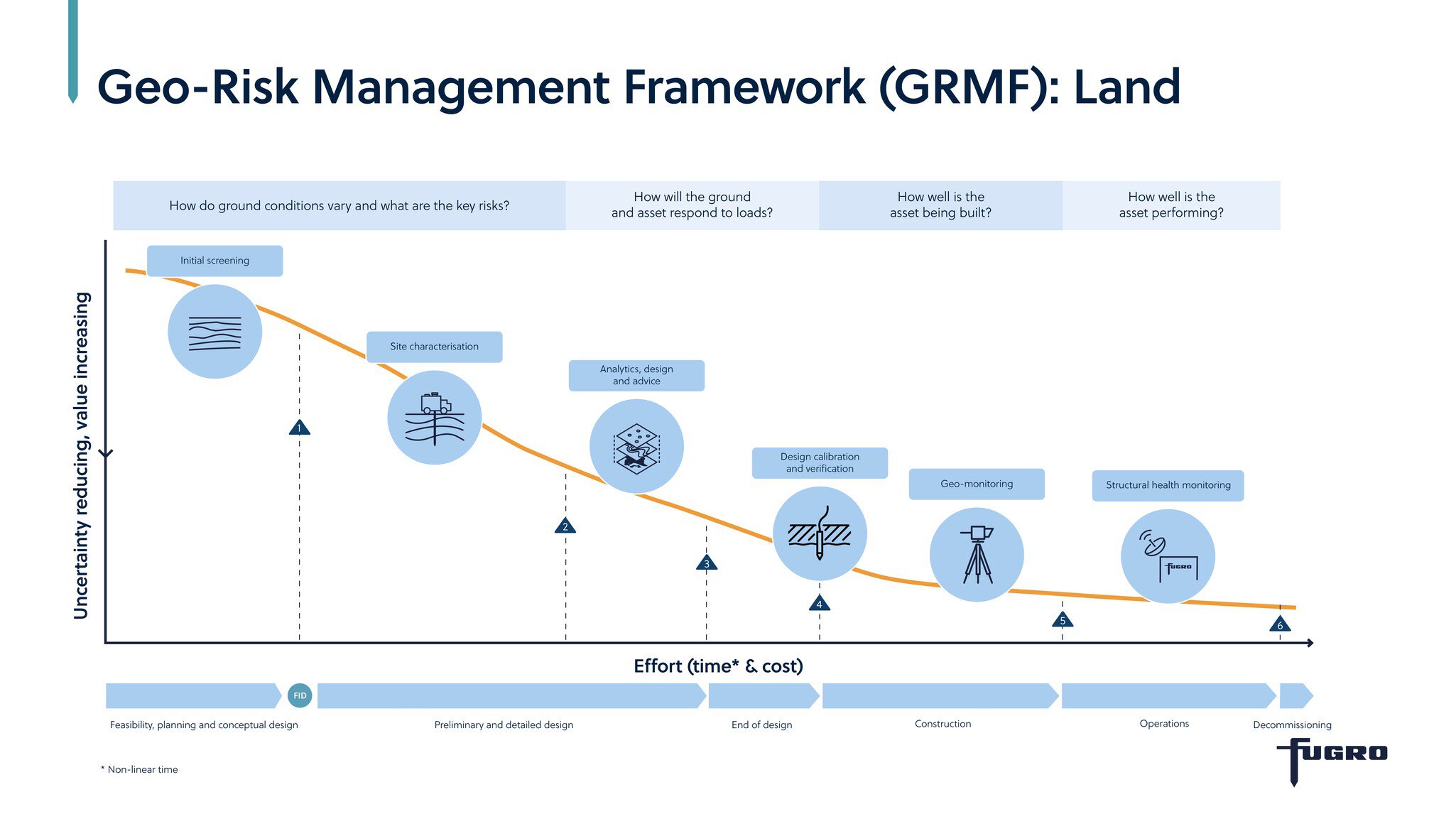
In construction, risk arises from uncertainty in the subsurface. As managers of risk, we aim to add value throughout the asset life cycle by reducing uncertainty and thereby minimising client exposure to subsurface risk. Our Geo-Risk Management Framework is an internal tool that we share openly with our clients. The GRMF addresses the key questions that define uncertainty for a project through a number of linked Fugro solutions comprising expertise, services, technologies and resources.
What is the framework?
The GRMF describes the subsurface risk environment that we share with our clients as project stakeholders. It brings together 25 years of knowledge and understanding about the vital role that geotechnics and other disciplines play in civil engineering. Each of the six solutions of the framework is underpinned by a portfolio of competence and technology.
We don’t use the GRMF to deliver off-the-shelf solutions. In fact, without an understanding of our client’s challenges and needs, the solutions start as empty shells and undefined. Through the eyes of our clients, we then use the GRMF to assemble relevant components (expertise, services, technologies, resources) into appropriate solutions tailored to each client’s needs, designed to reduce uncertainty and enabling them to meet their engineering business objectives.
A worthwhile investment
Understanding the ground conditions and how they will behave under the influence of the structure that’s going to be built is hugely beneficial to our clients. This knowledge will often initiate the development of design methods and solutions that are far more efficient and less costly to construct than traditional, overengineered alternatives.

Geo-Risk Management Framework diagram
“The framework helps clients see the improved value for money that comes from driving down uncertainty.”
Ray Wood
Director of Land Site Characterisation
The framework helps clients see the improved value for money that comes from driving down uncertainty to the point where you minimise or even eliminate the unforeseen consequences that often cause projects to overrun in terms of cost and time.
The ground investigation budget is usually 1 % to 1.5 % of the total capital cost. We have seen examples where reducing the uncertainty by spending another 0.5 % on ground investigation and advanced testing can reduce the geotechnical construction costs by 20 %. The framework demonstrates that.
Initial screening – an ‘MRI scan’ for constructors
The framework can also improve the delivery of the ground investigation itself.
The Initial Site Screening solution provides a good example. It gives an early indication of variations in subsurface conditions and ground risks, both of which drive the design of the subsequent intrusive investigation.
On some sites the initial screening can be pretty challenging because of access and permitting issues. To overcome these difficulties, we developed a passive seismic system that we leave on site for up to a week. Advanced processing of the seismic records allows us to deliver a 3D model of geotechnical properties to a reconnaissance level.
Having an MRI scan ahead of a hospital operation informs the surgeon what to expect before picking up the scalpel. Exactly the same principle applies here: the initial screening phase enables our clients to understand the ground conditions on site long before construction work begins.

3D model of initial site screening
The proof is in the pudding…
In 2019, we used the framework approach to develop a ground investigation for a polyhalite mine tunnel located below a National Park in Yorkshire, England – an area known for its complex geology.
For this challenging project, we were tasked with investigating the route of a 37 km long tunnel located more than 250 m below ground level. We applied our framework approach: initial site screening, then integrated digital site characterisation followed by analytics, design and advice.
Through the resulting digital deliverables, including geo-risk maps and a ground model, we enabled the client to identify – and take steps to reduce – the main risks that the tunnel boring machines were likely to encounter.
In summary
Our new framework approach to site characterisation can reduce ground-related risks and enable clients to achieve leaner design and construction solutions.
We’re continuously refining and improving the process – each solution within the framework is underpinned by advances in engineering, technology and data management.
Did you know?
Spending another 0.5 % on ground investigation and advanced testing can reduce geotechnical construction costs by 20 %

What we do at Fugro